
Hello dear readers and thanks for checking out the 15th day of my walk round the London LOOP orbital path. I know there was some confusion in the last entry but I am fairly certain now that this is indeed the 15th day of walking. If you’ve been reading the previous posts then just skip down to the read more button as the next paragraph is merely a cut and paste of an earlier one for the benefit of readers who may have just landed here.
The London LOOP is a little over 150 miles of designated and way-marked public right of way which is just concentric to the M25 motorway and as always I start with a quick word of advice. This post is one of a series and it will make more sense if you start at the beginning to discover what lunacy had compelled me to undertake such a large project.
So, Day 15 (probably!) but will it be the last? If you read the previous entry in this series you will know that I left you at the depressing Hatton Cross tube station looking like a drowned rat after a day of torrential rain and having had to wade my way through puddles that would more properly be described as paddling pools or small baths.
I also mentioned that it was about 11 miles covering the last two sections (as per the TfL website, the official guide book has different sectioning) to get to Uxbridge which would mark my completion of the entire LOOP. That should be possible and I set out to see if it was indeed feasible a mere four days after the last outing and the weather could not have been in starker contrast, it was a fine sunny morning.
If indeed I have already had 14 day’s walking with that distance left then it means, even with my abysmal maths, that I was averaging about 10 miles a day and I know this section is dead flat so it should not be too much of a problem but will I do it? Will something unfortunate befall me so close to the finish as it did to poor old Jim Peters?
If you have never heard of Jim Peters, he was a tremendous marathon runner who in 1953 was the first man ever to run a sub 2:20 marathon which was then the distance equivalent of the sub four minute mile. That distinction had gone to another Englishman, Roger Bannister, less than three months previously. In the 1954 Commonwealth Games in Vacouver, Peters absolutely destroyed the competition and arrived back at the stadium a massive 17 minutes ahead of his nearest rival and an equally incredible 10 minutes inside the world record. Within sight of the tape he collapsed and despite repeatedly trying to continue he could not and did not finish the race. He was stretchered to hospital seriously ill, nearly died and never raced again.
Thankfully, the gallant Mr. Peters was far from my thoughts as I set out to metaphorically hopefully “breast the tape” at Uxbridge some time that afternoon. If, for whatever reason, I didn’t make it that day it wasn’t going to be a problem, there would always be another day and I had never set out on this slightly mad journey just for something to do, it started out as a whim. To be honest, having got as far as this I thought it would be pleasing to achieve it but I certainly wasn’t going to beat myself up over it if something went belly up.

It wasn’t too difficult a task to stride out at the beginning as I wanted to put as much distance between me and that awful Tube station as possible and, frankly, Hatton Cross itself. No disrespect to those that may live there, although I simply cannot imagine why anyone would want to live on the flightpath of the busiest airport in the world, but it is an awful place. Until the coming of the aeroplane and London Airport which is now better known simply as Heathrow, it was a sleepy little rural hamlet in the middle of a heath, hence the name.
It must have been peleasant enough as King Edward III built a house in Hatton and it is recorded that his grandson, the future King Richard II visited him there. Today, it a soulless, ugly modern place whose only raison d’etre is to act a service centre for the airport, complete with a plethora of identikit international chain hotels, airline catering kitchens, logistics depots and all the other appurtenances of a major transport hub.

Straight back onto the dreaded A30 which actually seemed a whole lot more pleasant in daylight with a bit of sun and minimal traffic due to it being a Sunday. I found the path easily enough and in exactly thirteen minutes (I checked my image times and I hope there are no triskaidekaphobics reading this) I was in a different world, albeit a very noisy one. I was directly under the flightpath and no more than 1500 yards from the end of the runway. This is not hyperbole, look it up on the map if you don’t believe me, I just did. There is something decidedly odd about looking up at the underbelly of a 747 with the landing gear down although I suppose it is infinitely preferable to watching one coming in with the landing gear up!

I was in Cranebank Nature Reserve and apart from the thundering of Rolls-Royce jet engines overhead I could have been out in the country somewhere. I didn’t stop to look for one of the water voles that apparently live in those parts. I’ve never actually seen a vole but I’d like to as I think they are adorable little creatures and I knew they were endangered but not that they are listed as the most endangered mammal in the UK.
Vole numbers have fallen by 97% since the 1970’s which is terrifying. Not only is their habitat constantly reducing but they are being slaughtered wholesale by invasive American mink. I think we should protect our native species against these invaders, anyone for a nice coat? That was a JOKE, so let’s not have the anti-fur lobby getting on my case. I have always thought that pelts look a whole lot better on the creature that grew them.
I only found this titbit of information just now as I write this in December 2020 and I found the information here when I was researching exactly how endangered the vole is. If you have not checked out the link above, it is an article on the Natural History Museum’s website, dated only two months before I wrote this and it deals with a scheme by a charity for the re-introduction of voles into the wild. Good work those people.
This is all well and good but it also reinforced a belief that I have long held and that I have spoken of on this site many times. I am convinced that everything goes round in circles, and I am not just talking about the London LOOP here which most certainly does go round in a very big circle. I think it was best summed up by the brilliant late Douglas Adams (of Hitchhiker’s Guide to the Galaxy fame) in his Dirk Gently series of books when he speaks of “the inter-connectedness of all things”.
What is he wittering on about now, I hear you say. Well, what river are the voles being re-introduced into, where is this excellent scheme taking place? Kingston-upon-Thames where you will remember the last day’s walk in the rain started and what river are they being re-introduced into? None other than the Hogsmill which I had followed for most of the day before last on the LOOP. Before I walked the LOOP I had never even heard of the Hogsmill and only learned about it whilst researching for this blog series. I rarely go to Kingston and, indeed, have not been there since that day back in 2014. I cannot remember the last time a vole ever entered my mind and yet here I am “joining up the dots” as it were.
In the strange way my brain works I have just been wondering how many WordPress (the site I use to compose these entries) blogs have vole as a tag in the tag cloud. Probably not too many. Have I gone completely mad? Most likely, but I am not dangerous. Enough of my pholosophical musings and back to Cranebank and today’s portion of the LOOP.
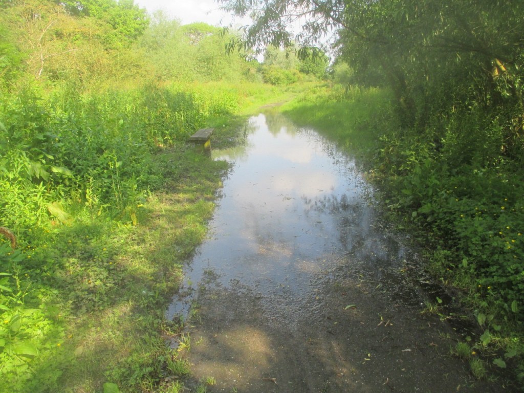
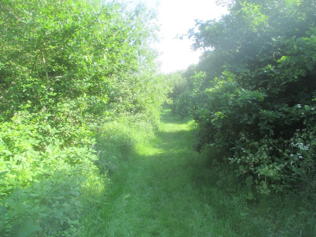
My boots had just about dried out since their soaking four days earlier and I had decided to wear them rather than my trainers even though it was bright sunshine and I knew the walking was all on surfaced paths. A look at the image above will explain to you why I was so very glad I made that decision. There obviously had not been quite enough sun and by the look of that small lake I reckon it was determined to last the summer out.
Were it not for the bench I could have told you that this was another image of the Crane River and you might even have believed me. We are walking upstream and the genuine river is not a lot wider than this here and probably not much deeper in normal circumstances. I managed to negotiate a muddy route to the left, thankfully without ingress to the trusty old Line-7’s. I miss those boots so badly.
Having regained terra firma, it was a short walk through a residential area until I emerged onto the A4 Bath Road which until the M4 was built was the main route to, you’ve guessed it, Bath (and Bristol and just about anywhere else in the West Country). Like most of the major arterial roads into London it is normally very busy but with it being Sunday it was not too bad and a short walk brought me to Cranford Bridge as I was now in the area of of that name.
I know my readers are all intelligent prople, slightly bonkers perhaps as evidenced by your continuing to read this disordered rambling, but intelligent nevertheless so take a wild guess why this is called Cranford. Yes, you got it but in view of my international readership, and that is not a boast but a statment of fact, 64 countries so far, I shall take a moment here to explain a little about British placenames for those who may not know.
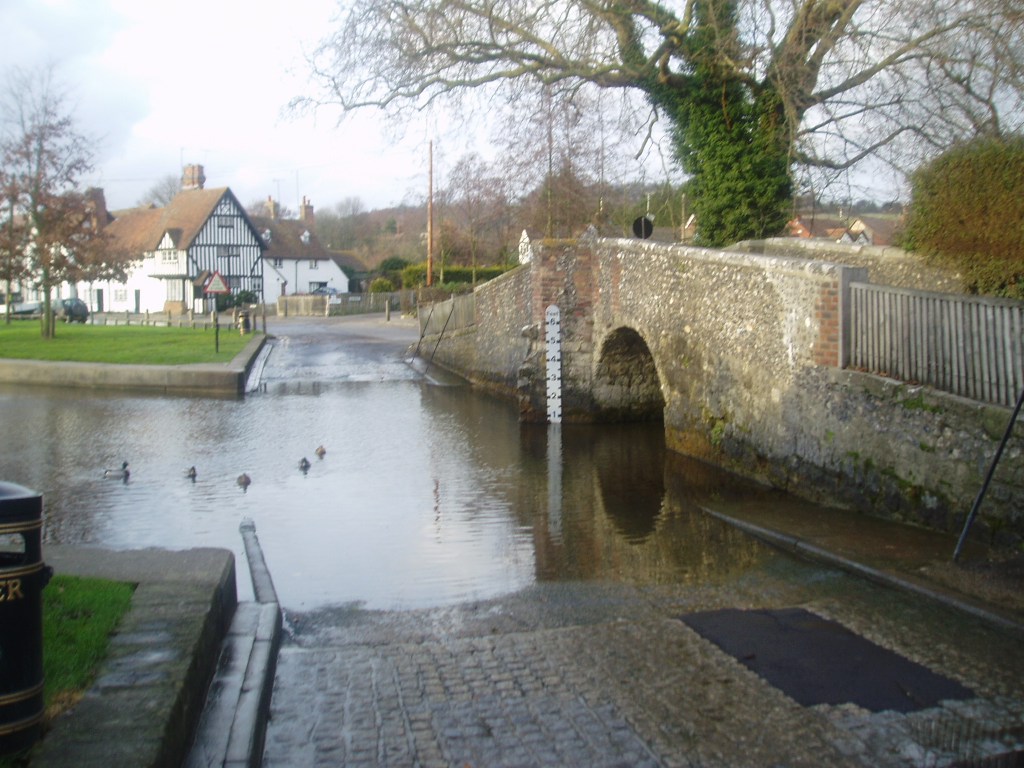
Anywhere in UK where the name ends in “ford” means there was a crossing place of a river there in the days before there were many bridges. Think of Oxford, Fairford, Duxford etc., there are literally thousands of them. Ford is merely an old English word for such a crossing place where the water was shallow enough to wade or drive beasts across. I have included an image below to give you an idea of what I am talking about.
This ford is at Eynsford in Kent which sort of proves my point about the naming system. There are no fords on the London LOOP as we have built so many bridges, indeed they are a rarity now except in some very remote rural areas but this is the only image I have in my collection. It is not on the LOOP but, believe it or not, this wonderful little village is less than two miles from it.
Here endeth the lesson on toponomy (go on, look it up, I had to) although it is yet another thing that interests me which seems to include just about everything. A dear friend of mine is a librarian and reads this nonsense, I’ll bet she knew what the word was. You know who you are, so hello and thanks for reading. I won’t embarrass you by naming you, just pop the cheque in the post!


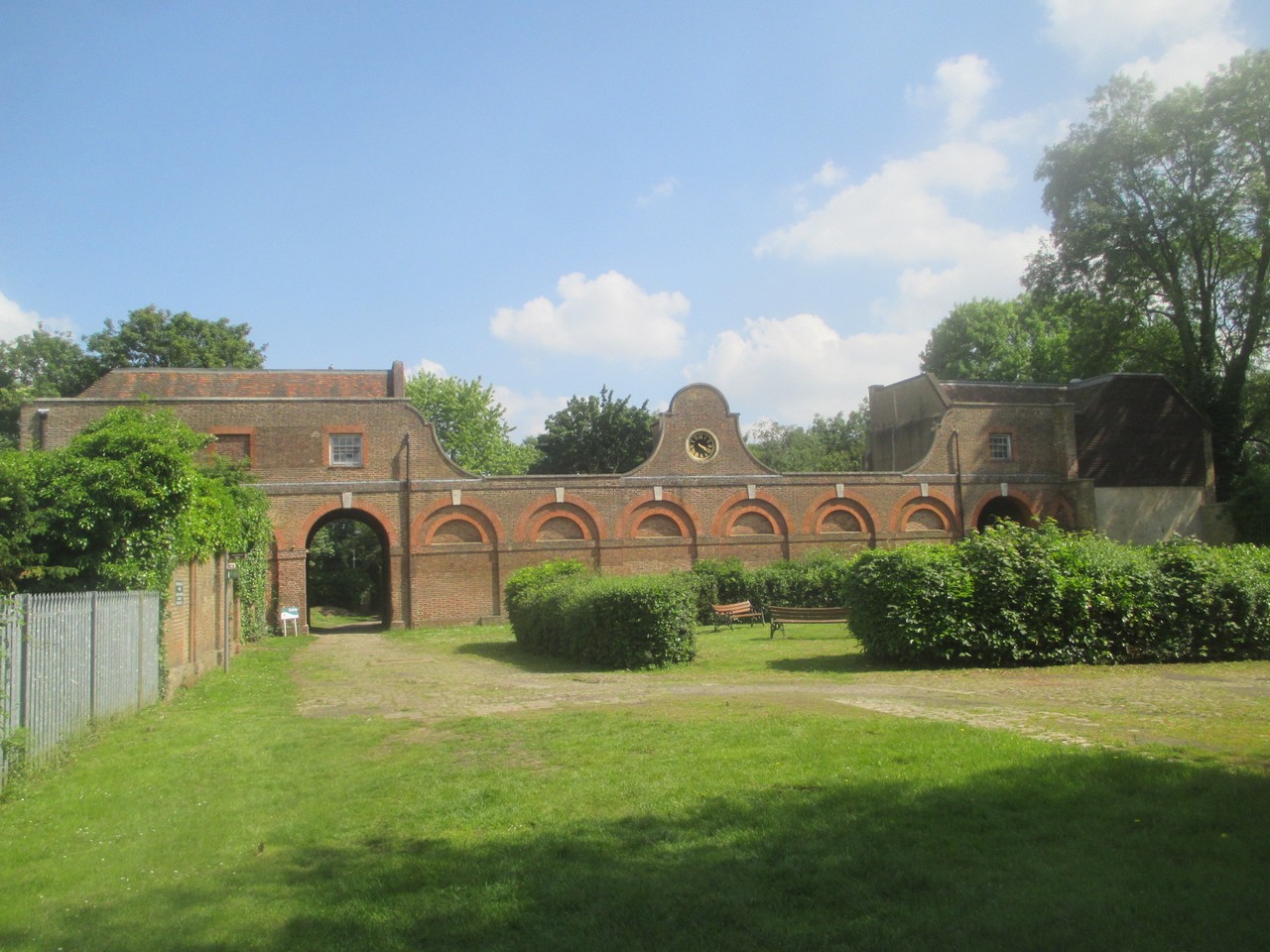
What can I tell you about Cranford Bridge? I am ashamed to say that apart from the information which you can read for yourself on the image, I can find out precious little. It sits in the ancient area of Elthorne Hundred (the term Hundred having long since died out) and it seperates the London Boroughs of Hillingdon and Hounslow. Actually, it does not even do that, it is the river that performs that function. There was a bridge here prior to 1274 and it was classed as part of a “principal highway” (a mediaeval motorway, I suppose) in 1593.
That was as much as I could initially find, which is why I wrote what I did and I was distraught. I thought I had failed my poor, dear readers. I thought I had let you down and was just about to go on eBay to order in some sackcloth and ashes. Regrettably, I have to outsource as my potatoes come in plastic bags instead of sacks and I live in a smokeless zone where I am heated by electric. I thought of my wonderful readers and I persevered and found something that led on to something else and which you may find vaguely interesting. I do hope so as it nearly drove me nuts finding it. It concerns the road I was then standing on.
Prior to the early 18th century, the upkeep of the roads in England, such as they were, was a fairly haphazard affair administered on a Parish basis by Justices of the Pace (JP’s) who had the power to enlist the parishioners as free labour. Again, for readers who may not be aware of the concept, I should explain JP’s.
The office of JP began with King Richard I (aka the Lionheart) who appointed certain of his knights to keep the peace in their respective areas, hence the term JP. I don’t want to metaphorically wander too far from the London LOOP here so, to precis, the office continued through the centuries and remains in the UK in a slightly diluted form and in many countries, mostly those that were formerly in the British Empire, although both the USA and Belgium also employ similar systems.
The JP is typically a respected member of the community who exercises minor legal powers like arraigning people to a higher Court, signing certain legal documents, issuing warrants etc. They could also hear minor cases although in the UK this practice is normally performed by trained lawyers now but JP’s still have the authority to do so. The appointment is for life and is not subject to renewal or re-election and is conferred by the Lord Chancellor upon local advice as to who may be suitable. My recently deceased Father was a JP.
Regarding the early 18th century roads, standards varied hugely, dependent upon how active the JP was and how willing the local Parish was to supply funds and many roads were in a parlous state so Parliament took a hand with 1663 Act of Parliament requiring travellers to pay a small amount to use a section of the Great North Road which runs from London to Edinburgh, the first toll road in the UK. Although a naturally unpopular measure it did raise the necessary funds and in 1706 a further Act was passed which extended the concept and established Turnpike Trusts.
Turnpike Trusts were given a particular stretch of road to administer on a non-profit basis with all the funds supposedly going back into the upkeep of the thoroughfare although obviously this system was open to abuse. The JP’s still retained a certain role, primarily ensuring that the local populace still provided the free labour required for “highway maintainence”. The scheme was widely and quickly adopted and by 1770 over 1100 Trusts administered 23,000 miles of road by means of 7800 toll gates.
In 1717 the 12 mile Brentford turnpike was established from Kensington in West London to Hounslow where it divided. The Southern route continued on along the Exeter road and the Northern portion ran up to Cranford Bridge so it could join onto the Bath Road. The roads were controlled by officials collecting the tolls and to stop people evading the charge, poles or pikes (think of a pikestaff on a weapon) were placed across the road to bar it. This pike was turned aside to allow passage on payment of the toll, hence the word turnpike which continues to this day. Eventually, gates were erected bu the term turnpike was firmly established by then.
By virtue of this Cranford Bridge was already an important part of an increasingly organised transport infrastructure but 10 years later it was to become the terminus of another toll road. A partial record exists of a meeting of 1st june 1727 which led to the establishment of the Colnbrook Turnpike Trust which was allocated a 17 mile stretch of the Bath Road (which is where we are now standing in case you had forgotten with all my digressions!) between here and Maidenhead Bridge just outside the town of that name in Berkshire. Clever thinking to put the tolls at bridges so people could not easily dodge round them. Cranford Bridge was now, therefore, what in modern parlance would be described as an interchange or transport hub.
With the coming of the railways in the 19th century road use declined rapidly as road haulage just could not compete for speed or cost. The Colnbrook Turnpike Trust, which was incidentally named for a river which runs a couple of miles West along the A4 and a village of the same name, was finally dissolved in 1871 when the administration of the roads passed to more centralised control. So there you have it, I knew I could find something to hopefully interest you.
Wet footnote (as it refers to wet feet).
Whilst researching this portion of the blog I had to smile when I discovered reports of an article in the “Gentleman’s Magazine” of September 1754 which complains of the road across Hounsow Heath frequently being two feet deep in mud. If you have read my previous blog entry here you will understand when I utter a very heartfelt, “Tell me about it, plus ca change”!
Just beyond the bridge I turned right into what I now know is Berkely Meadow and this name is important as we shall find out shortly. The Meadow is now a pleasant and well-maintained open space with a children’s play area and, even on a pleasant June Sunday morning, I had it all to myself. Leaving the Meadow and crossing Cranford Lane and the delightfully named Frog’s Ditch I found myself in Cranford Park and I certainly had no problem finding things to tell you about it as the history is fascinating, at least I hope you think so.
The first thing to tell you about Cranford Park is that it is an anomaly in that it lies on the Western bank of the Crane which I explained is the Borough boundary. The Park lies in Hillingdon but is administered by Hounslow. Don’t ask me why and I thought that researching that would be a bit excessive even for me so let’s look at some history instead.
It is known that there was a Roman capita ( a “little chapel”) here but we shall come to that in a moment. After the Roman withdrawal from Britain the area was settled by Saxons who remained in control here until Britain was invaded again by the Normans in 1066 whereupon they basically took over the country by right of conquest. In the 12th century the area hereabouts was granted to the Poor Fellow-Soldiers of Christ and of the Temple of Solomon, who you more probably know as the Knights Templar. It was given to them by John de Cranford (note the French name). The Templars were a warrior priest Order originally set up to engage in the First Crusade and re-capture Jerusalem and the Holy Land from the Musselmen (Moslems) which they paritally did, capturing the Holy City but never fully controlling the region.
The Templars metamorphosed into a group dedicated to protecting pilgrims making the journey to Jerusalem and incidentally laid the foundations of the modern banking system in the process. Having grown “too big for their boots” the established Church which had spawned them plus several jealous and / or fearful rulers, primarily King Philip IV of France, had the Order dissolved in 1312. After somethig of a show trial featuring confessions obtained under torture it’s senior officers were burned to death in Paris on 11th March 1314. Although it lasted just under two centuries the Order was easily the most powerful military organisation in “Christendom” although it’s influence was much greater than merely martial affairs.

The land here at Cranford is merely a minute fraction of the huge holdings of the Templars and, after the dissolution of the Order, the lands reverted to the control of the nobles descended from the Normans and their descendents in turn. With the Reformation during the reign of Henry VIII the Parish was granted to Henry, Lord Windsor, one of his cronies, and his family held it until 1604 when it was purchased by Sir Robert Aston. Sir Robert did not enjoy his purchase long as he died here in 1612 whereupon his heirs sold the property to Elizabeth Carey, Lady Berkeley who is herself a fascinating character.
Elizabeth was the only child of George Carey, 2nd Baron Hunsdon and Elizabeth Spencer of Althorp, Northamptonshire, a family you may have heard of. The Spencers still hold the land at Althorp and undoubtedly the most famous member of that family was a certain Lady Diana. Elizabeth Jr. was born into the very upper echelons of mediaeval society and Queen Elizabeth I was one of her godmothers. When she married Sir Thomas Berkely on 19th February 1596 at the age of 19 the entertainment may have included the first ever performance of Shakespeare’s Midsummer Night’s Dream (other claims are made).
Sir Thomas was a bit of a clown regarding matters financial despite his huge wealth and amassed huge debts which poor Lady Berkeley had to sort out upon his early death at age 37 in 1611. She had to sell some of her properties to meet these debts but still obviously had enough money to buy Cranford in 1618 for the sum of £7,000, a bargain! Is this what is known in modern parlance as “consolidating your portfolio”?
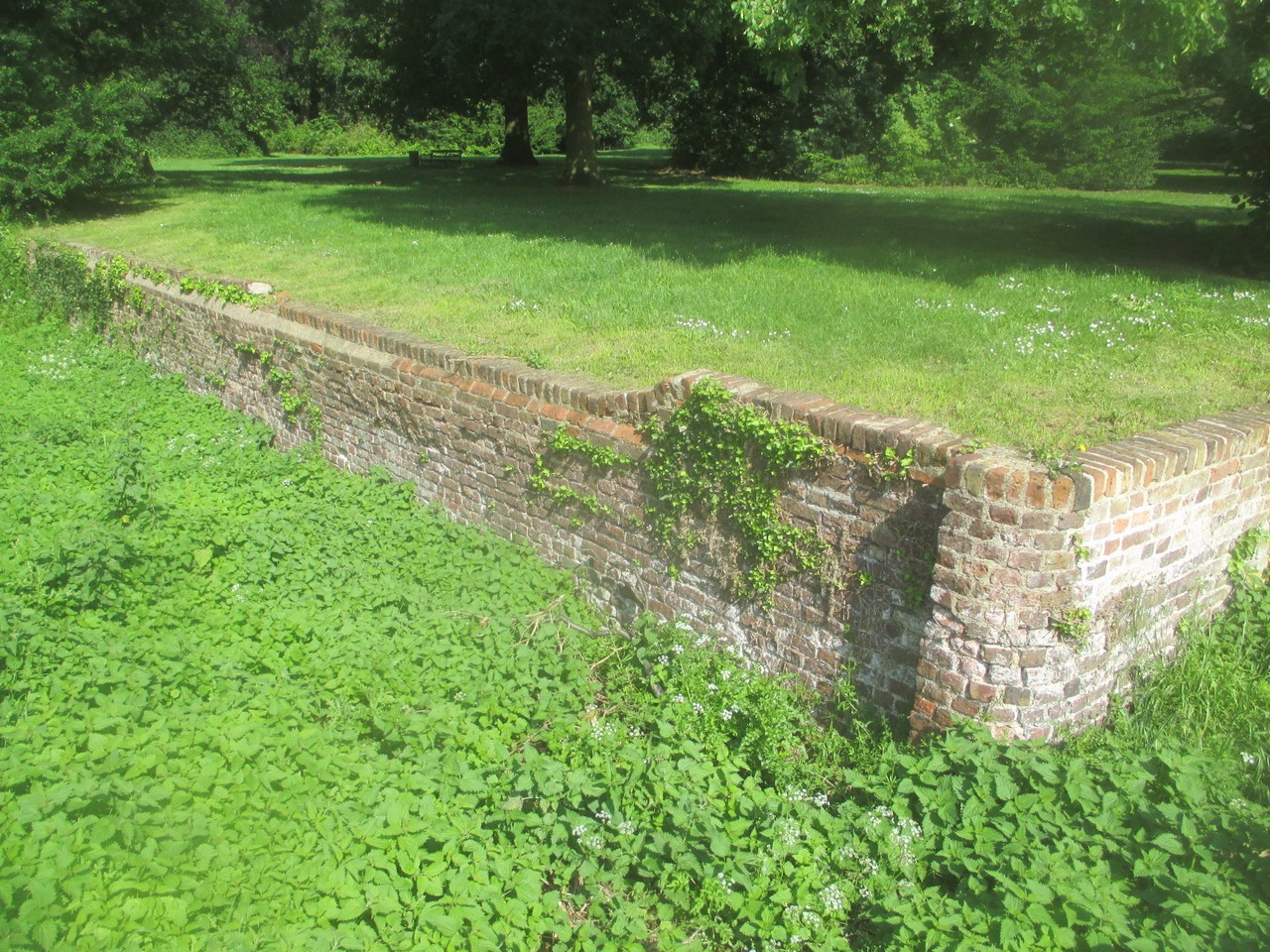
Lady Berkeley remarried Sir Thomas Chamberlain in 1622 but they retained Cranford and it was to remain the family home for exactly three centuries until 1918 when it was abandoned and left to rot to such a degree that it was demolished immediately after World War Two although some small remains and the impressive wall you can see here still remain. The house may be long gone but the family connection most certainly is not. Whilst Cranford Park may now be maintained by a Council whose jurisdiction does not even cover it, the land remains in the possession of the direct descendants of Lady Elizabeth to this day. What about that for a bit of continuity in local affairs.
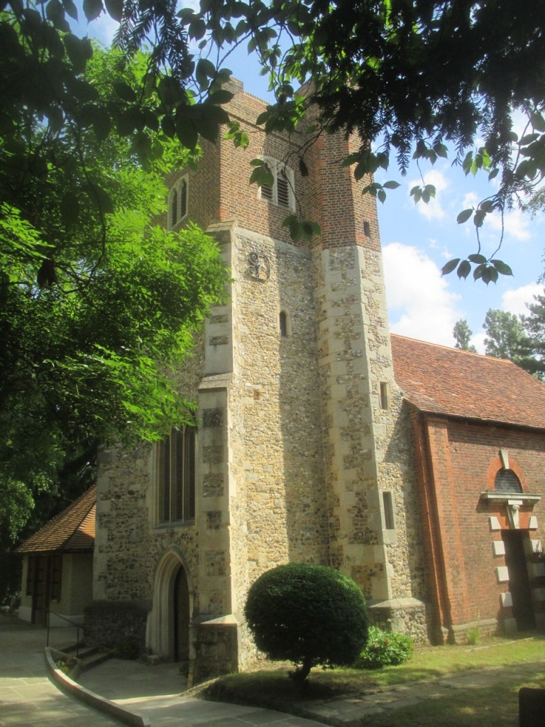
Poor old Lady Elizabeth did not have much luck regarding the longevity of her spouses as Sir Thomas died in 1625, pre-deceasing her by some ten years. When she died on 23rd April 1635 she was buried in the Church of St. Dunstan and Holy Angels which stands at the North end of the grounds and is undoubtedly the jewel in the crown that is Cranford Park and you’ll not be surprised to know there is a fair amount of history associated with that building as well.
We know there was a Church here in the reign of Edward the Confessor who ruled 1042 – 1066. This Church was built on the site of the Roman capita I mentioned earlier, as were many Churches of the period. This was a SOP (standard operational procedure) for the Church who had a deliberate policy of using old pagan sites, festivals etc. so as to make their new religion more acceptable to the populace.
Perhaps the best example of this is Christmas Day. Historical evidence proves that the census which allegedly brought Joseph and Mary to Bethlehem was not in December. The Church merely “hijacked” the pagan midwinter festival which was (and still is) celebrated at the winter solstice. It was the Church that decided on the present date in the early fourth century as part of this deliberate policy of peaceful, and sometimes not so peaceful subjugation of the pagans. The policy was even formalised by Pope Gregory I who told St. Augustine and his colleagues to “utilize the sacred places of the Pagans for the service of the true God, and to adapt them to the uses of the Christian Church.” Hence the Church here at Cranford on a Roman sacred site.
When the Normans invaded in 1066 they too set aut subjugating the indigenous population in a considerably less peaceful manner than the Christian missionaries. There were two main planks to their strategy. Firstly they built the hugely imposing Norman castles, many of which remain to this day, as a daily reminder to the “natives” who was in charge now and to act as a powerful military deterrent to any who might have thought otherwise. Secondly, they rebuilt many Churches in their own style. The old Saxon buildings had been mainly of wood but the Normans replaced them with stone structures, mostly to a fairly standard design. This often included a tower to the West end of the building serving as an entrance (and often belltower) because the East end of a Church was reserved for the alter in order for it to be nearest the Holy Land.
I should mention at this point that the tower you see today is not an original Norman structure but it’s 15th century construction makes it the oldest part of the building. One of the bells in the tower predated it by some years, having been cast in 1338. It is said to have rung out on every occasion of national importance since. The entire building survived a serious fire in 1710 and the repairs were entirely funded in 1716 by another Berkeley and another Elizabeth, the Dowager Countess. I am taking a bit of a guess here but I suppose she would have been the granddaughter of the original Elizabeth. So many Elizabeths, was nobody called Britney or Skye in Georgian Britain? Enough, Fergy.
I am conscious that this entry is becoming lengthy, even by my own appallingly verbose standards and so I think this would be a convenient place to take a break so it does not get too unwieldy or you, dear reader, fall asleep, collapse from exhaustion or lose the will to live.
I promise you that there is much to see in the inside of this ancient church, and there is still a lot of walking to be done before quitting time as we have not even finished the first three and a half mile section yet! If you want to come into the church with me, discover what else I saw that day and learn whether or not I get to my ultimate destination of Uxbridge you’ll just have to stay tuned and spread the word.
