
Hello there and welcome to the second day of my walk along the London LOOP path. If you have come upon this page other than by way of the introductory page, I suggest you start there as the whole thing will make more sense. Just go to the bottom of this post, press the previous button and you’ll be there. Effectively, I am writing about a 150 plus miles way-marked path which circumnavigates the periphery of London and this is the second chapter of my journey round it.
I was still fairly early into my travels and took a nice new “Underground” train to my start point of Moor Park where I had left off the last time. To be honest, most of the route was actually above ground but it is still known as the Underground even if the majority of it isn’t. Don’t you just love British eccentricity?. We are still very much in Sir John Betjeman’s “Metroland” here as my use of the Metropolitan line indicates. The great poet named an entire swathe of the environs of London to the North and Northwest for this public transport facility.
 I have been very vocal in my condemnation of Transport for London (TfL) here and elsewhere. TfL are the body charged with overseeing transport in the capital and I believe I am right to criticise them as I still find them abysmally incompetent in most respects. I do believe in fair reporting, however, and the new rolling stock on this line was really rather good.
The image also makes a useful point about the LOOP walk, inasmuch as it is designed to be very accessible by public transport. As far as I can make out, having studied it in considerable detail, the entire route is accessible on public transport which is within the area covered by the Oyster Card. This makes it a wonderful amenity for Londoners or even visitors wanting to spend a day away from the mayhem of central London.
 So, here I was again, full or enthusiasm and raring to go. Having walked into this station, I knew exactly where to go and here is my tip for the walker if they are doing only one section. When you descend from the platform, which is raised, turn right and go out of the “back” of the station. If you see a road and some shops you have gone the wrong way, you are looking for what is no more than a country footpath. I have included this rather poor image just to provide a visual reference so you know you are in the right place
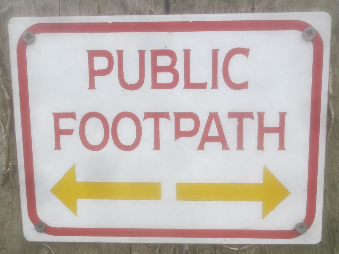
 You should see this sign to your right to show you that you are on the right path. It is typical of the generally excellent signage that is a feature of the entire LOOP.
Just so you are in no doubt, this is the exit you want to be leaving by. Come out here and turn immediately right on the path along the golf course. I realise this is not very exciting reading for the average Fergysrambles reader but it may be of use to the traveller who wishes to walk some or all of the route and that is my aim here. I know the instructions in the guide book are fairly scant and non-existent on the website.
I should say that much of this and subsequent entries is in the nature of an instruction of how to navigate the LOOP which is how I originally wrote it on the Virtual Tourist website before transferring it here. Don’t worry, there will be my usual selection of history, observation and completely useless trivia as well.
 As the image above indicates, it was not the best of weather when I set off again but I was happy. I was really enjoying this walk. Retracing my steps for about half a mile from my previous days ramble, I was once again walking alongside and actually across the Sandy Lane Golf Course. The sign here is important.
The LOOP traverses many golf courses and whilst you do have a legal right of way, a bit of courtesy never goes amiss. If you come onto what looks like a tee, fairway or green, have a little look round and make sure there is nobody playing. If there is, stand still and let them get on with it. It will only take a moment and will much improve the image of ramblers with the golfers who, let’s be honest, pay a lot of money to play a game on these courses. On all my travels on the LOOP I found the golfers to be very polite, waving me across a fairway if someone was taking a minute or two considering a shot, returning my friendly waves and so on. There is plenty of room for all of us.
The last part of the sign is the most important. Many years ago when I used to hack around a course and never managed to break 20 for a handicap I used to hit many stray shots. With the greatest respect to the members of Sandy Lodge and all the other clubs I have walked over, it is not exactly the European Tour and even if it were the top pros hit the odd wayward one every so often. Keep your eyes open and if you hear a shout of “Fore” your best bet is to hunker down and cover your head with your hands and forearms.
I am not for one second suggesting that this is a dangerous walk but a decently hit #1 wood off the tee is going to really hurt if you collect it 50 yards down the fairway. The golfer isn’t going to be too happy either. You have been warned!
Having traversed Sandy Lodge Golf Course, you come to a minor road, turn right which brings you to a fairly major road with a filling (gas) station on the right. Cross the main road here with care and look slightly to the left for a fairly hard to find path.
 Follow that through and you soon come out to a lovely open space called South Oxhey Playing Fields. On the day I walked through there was a “gang” of teenagers riding miniature motorcycles about the place but, apart from the noise, they didn’t bother me. You should walk basically straight ahead and you will see a kids play area straight ahead. The way-marking on this section is not great which is why I am dealing with it here. Keep looking to your right and you will see this fairly basic vehicle access gate, this is what you are heading for. The way-marking here comes back in and you will have no problem.
 Follow the signs through a pleasant little suburban housing area but don’t panic, you will soon be back in the countryside. Literally ten minutes walk following the way-marks and you come upon this sign. Walk on and enjoy.

To reinforce a point I have been trying to make and hopefully not laboriously throughout this series of posts, I deliberately took this image. The image above of the Woods maker was taken at 1311 hours and this was taken at 1312. The first one was in a suburban street.
As I took the first image I looked to my left into the rear garden of a suburban house complete with the washing on the line. I was certainly not going to take an image of that as I would not intrude in such a way, but this beautiful place is genuinely within yards of a housing estate and this for me was the great revelation of the whole walk. The amount of open land, much of it very rural, within what is known as Greater London, is quite phenomenal.
 Without wishing to labour the point, this image was a mere 13 minutes later. From walking through a genteel London suburb, I was wandering through a lovely bluebell wood where you can obviously see the path. If you look closely, there is even a marker post in the middle of the image. You may need these sometimes as the LOOP follows and crosses a large number of other local paths so make sure you follow the kestrel mark which is the official logo for the LOOP.
 Whilst walking the path, I was completely amazed at the amount of livestock I encountered, specifically horses. I suppose those of us who reside in fairly central London have some sort of default mental position where we do not expect to see animals and yet I saw so many on this walk and horses seemed to be just about everywhere. I know the very rich trot their animals down the so-called “Rotten Row” in Hyde Park but now that the infernal combustion engine (no, this is not a typo) rules the world, the poor old horse has lost it’s position as a working animal. If you want to know all about Rotten Row you can have a look here as it features on the route of another London Walk I have reported on, the Jubilee Greenway.
Whoever owns this beast, it looked very happy. It made me smile and put a spring in my step for the next little part of the walk.
Not long after the delightful sight of the horses, the constant “obstacle” of the golf course arose again. As I mentioned above, I am firmly of the opinion that all types of people can use the open spaces together and there isn’t a problem.
 In this case, the path (a public footpath where I had an absolute legal right to be) continues round the back of a tee where some guys were about to tee off. I stood still and quiet so as not to disturb the chap addressing the ball and was going to carry on where my guidebook had told me when he hit his drive. One of the golfers engaged me in conversation and actually seemed to know about the LOOP. He thanked me for waiting on behalf of his playing partner and indicated that my best route was along the left hand treeline up to the green-keepers shed and then go onto the path. Seems like my small courtesy had paid off.
This is a tip for readers wishing to have a go at this themselves as you could get a little lost here. Just keep to the left and you will be OK. We parted with a friendly word and it was a great example of how we can all co-exist on the quiet places we have. OK, enough moralising, so back to the route now.
 Having negotiated the flying balls of the 15th hole (or whatever it was, I never looked!), I wandered up what was obviously a track to the road. My guide book had indicated that I should go left and follow a path along the ancient Grim’s Dyke, having first checked the memorial plaque to that ancient monument. Well, that was easier said than done.
Again, and apologies to those of you reading this as armchair travellers but a here is another tip for those who may wish to walk the path. The sign in the image here is virtually invisible in Spring / Summer due to growth. If you get to the road then you have gone to far. Retrace your steps and look to your right as you do. You will see a fairly unappealing hole in the hedge but that is where you need to go. I really wish they spent as much time here as they do on the greens! In fairness, that is not their job, the local councils are legally required to keep these paths open. Some discharge that duty much better than others!
Having eventually found the path, I wandered along looking for Grim’s Dyke. I do like history from all periods and I was looking forward to having a look at a Viking earthwork so close to London. Vikings this close to the modern capital, that would be interesting.
Well, I do like to look around me as I walk and I am not completely ignorant about ancient places, so I was desperately trying to find this earthwork / dyke / emplacement / fortification / defence or whatever you may like to call it. Did I see it? Did I Heck as like! I understand that the path follows the route of that emplacement but there is really nothing of it to be seen there.
Grim’s Dyke is one of a series of such emplacements all over Southern England with the same generic name although this is confusing. Grim derives from Grimr, a Norse word for the god Odin / Woden but the dykes predate the Vikings by centuries, having been constructed about 50 AD, possibly by the Catuvellauni tribe and expert opinion is very divided about them. Some postulate that the Southern English indigenous tribes built the dykes as defences against the Romans but others state that they are too small and were merely boundary markers to delineate the territories of the various tribes. I am not nearly clever enough to know so I’ll leave it to the historians and archaeologists to work out.
As a piece of even more ridiculous trivia than my norm, the dyke lent it’s name to the telephone code for the area which is 474 and equates to GRI on the old ‘phone dial.
Here is some more related and probably useless etymological (get me with the big words!) trivia. When Christianity arrived on our shores and drove out the old pagan religions the word grim became conflated with the Devil, presumably as part of the disinformation propagated by the new religion to discredit the old. The former fishing town of Grimsby literally means “place of the Devil” and I am sorry but if you have the forename or surname Graham or Graeme then you are tarred with the same unfortunate brush. Don’t say I never tell you anything!
 If you do manage to find the pretty anonymous little path that leads from the service road to the very busy alleged “minor” road beyond, you can beat your way for a very few yards along and then the going becomes a lot easier, it is worth it.
After a few hundred yards, you can glimpse the quite magnificent building you see in the image. It really is a quite magical sight appearing out of nowhere as you wander along what is effectively an overgrown path in what seems like the middle of nowhere.
Whilst it is a fine looking place, it has sad piece of history attached to it. The house dates from 1872, built to the design of Norman Shaw (1831 – 1912), a prolific architect. As well as numerous grand country houses, he also designed the original New Scotland Yard in central London, now renamed Norman Shaw Buildings and used as government offices.
Grimsdyke House is now a rather posh hotel although it is often used as a film location and it is not hard to see why. For the film buffs episodes of the Saint, the original Doctor Who and the Avengers (who remembers them?) were filmed here as was some of the 1969 film “The Prime of Miss Jean Brodie” starring Dame Maggie Smith.
It holds another secret as well and one that I, despite my dogged determination to find things out, will never get to the bottom of. For a couple of years prior to and some years after World War Two, the building was administered by the Charing Cross Hospital and used for recovering TB patients. During the War, it was requisitioned for the war effort and what it was used for is still classified with the documents not due for release until at least 2040. I’ll put a note in my diary!
 The most famous occupant of the building was undoubtedly W.S Gilbert, the lyricist of the Gilbert and Sullivan partnership, famous for their many light operas, who purchased the property for £4,000 in 1890. Sadly though, it was to be his undoing as he was to drown in the pond at the front of the estate after suffering a heart attack whilst trying to save a young woman in 1911. This innocent looking body of water is the scene of his sad demise, although it has seen better days and it appears rather untended now which is a shame.
 Leaving behind the rather fine house I kept on although I did manage to lose the path a couple of times. I have to say the signage on this small section is not great. I was rewarded after a while with the fine view over Harrow Weald that you can see here, looking towards London. In days past the Weald was extensively quarried for the gravel here by commoners exercising an ancient right so to do. Although there is no evidence of it nowadays, it apparently completely ravaged the countryside hereabouts. If you do get a bit lost here, don’t panic. Listen for the sound of the rather busy road and head towards it, that is where you are going and there are numerous places to exit the woods onto it.

")

Cross the road, and please be careful doing so. As I said it is busy and everybody seems to want to drive fast along it. A little further on you will come upon this welcome sight, the Case is Altered pub, a very pleasant establishment.
The Case is Altered is a reasonably popular name for pubs in the UK and I had always thought it referred to a legal term, indeed in some cases (no pun intended) it may well do. The sign here, however, suggests an alternative explanation for the name. If you look closely at it you will see it depicts soldiers from the Peninsular Wars sitting outside a tavern called Casa Alta (High House in Spanish, I believe) and the name may be a corruption of that. I don’t know if I have mentioned it earlier but one of my self-imposed little tasks on this walk was to have a drink in every open pub that I found, which effectively renders the whole journey a 152 mile pub crawl! I’m happy with that.
 Forcing myself to leave, I re-negotiated the very busy road and dived straight back into the forest. Hard to believe that this picture was taken literally about 100 yards from the road I just mentioned.
 As I walked through a pleasant sort of country park I came upon this rather incongruous sight, a Second World War pillbox. I know there are thousands of them still dotted around the country as I suppose they are just too much bother to demolish. Certainly I can see no military reason for them in the 21st century even if we still had enough troops to man them! Looking around a bit more, I saw large, well-maintained fences, barbed wire, guard dog notices and Heaven knows what else. I was intrigued now.
 This rather magnificent building is the reason for all the security although this is the closest I could get and I had to resort to the guide book to find out what it is. It is, in fact, a place called Bentley Priory and it has a fascinating history.
The site did actually house an Augustinian Priory founded c.1170. This was torn down and the building you see now was built in the 1770’s to a design by the famous architect Sir John Soane for the Marquis of Abercorn. Obviously various changes have taken place since then. I had known of Soane and visited his wonderful Museum and also his mausoleum, both in central London and if you want to know more about the latter you may with to have a look here. It features on another London Walk I was to undertake many years later and which is reported on in the attached link.
The building’s most finest hour was undoubtedly in the Second World War when it served as the Headquarters of Fighter Command including the period of the Battle of Britain. Indeed, it performed this function until 1968.
It is funny the way things work out sometimes. I walked this section of the LOOP in May 2013 and originally wrote it up in November of that year, resurrecting it for my own site now in April 2020. In the interim period between walk and original online posting, 12th September 2013 to be precise, it was opened by HRH Prince Charles, the Prince of Wales, as an RAF Museum.
Continuing past a rather posh looking housing area I continued on my way and had a bit of a look at my guidebook as I ambled along. This turned out not to be the greatest idea as it mentioned yet another pub, this time the Vine which it said was not actually on the route but just a short way off it. Well, given my own rules for the walk, I was more or less compelled to go there.
I approached from a side road and noticed the old-fashioned pub sign hanging high on the wall. It was only when I walked round the front and looked at the facade that I discovered this might not be your ordinary suburban boozer and I was right. Like the Case is Altered earlier in the day and several more I was subsequently to find, this place is effectively an Indian / Asian restaurant with a bar which is now properly called the Raw Lasan restaurant. Nothing wrong with that at all, it just feels a bit odd to me although the service was quick and friendly and they did have a proper pub selection of drinks as opposed to the limited selection often offered in a restaurant. Some of the meal deals looked to be excellent value as well. I only had a quick pint as time was wearing on and I had a bit to go, so off I went again.
 There is absolutely no reason for including this image other than it really is not what you expect to see on a walk you have started by Tube train. I did tell you there is a remarkable amount of fauna of all types on this route.

Heading towards Elstree which I had decided to make my finish point, I walked past the first of what were to be many reminders of what this area is arguably most famous for, namely film and television. To this day there are still studios round here and in nearby Borehamwood although nothing like it was in it’s heyday. I didn’t bother taking an image of the site as it is now redeveloped into a modern and fairly uninspiring industrial estate.
As so often with eeping this blog, the real interest comes later when I am writing it up. I had never heard of the Danzigers as I am not much of a film buff but I have discovered that they were Americans, Edward and Harry, who had both served in WW2 with Harry winning a Medal for Valour and Eddie attached to the legal branch where he served, post-war, as a prosecutor in the Nuremburg war crimes trials.
They had both been through London during the war and liked it so they decided to return. They bought an old aero engine factory (on this site) and set about converting it into studios from where they produced both TV and film. Adam Faith (popular 1960’s / 70’s singer / actor) worked here as a technician and the director Michael Winner and actor Michael Caine both worked for the brothers.
I am not sure if they got bored or for another reason but they decided to change tack and bought the Gordon group of hotels which included the Mayfair and Grosvener in London and the Metropole in Brighton. As an interesting aside, I discovered whilst researching Bentley Priory above that the house was the home of the head of this hotel group prior to being taken over by the Air Ministry. Ah, the inter-connectedness of all things!


Not far past the site of the old studios and another welcome sight, the rather modern looking Fishery pub.A quick pint whilst admiring the view over Aldenham reservoir and it was back to the path. Time was wearing on a bit, it was getting towards six.
 It is a flat and easy walk along the side of the reservoir as you can see. The reservoir was built in 1795 by French prisoners of war as the local mill owners were worried the nearby Grand Junction Canal would lower the water levels in local rivers.
Follow the signs and go across a couple of fields but be careful as you can go a bit wrong here, I did! Anyway, you will eventually come to Elstree Hill North. I knew I needed to turn left but, you guessed it, I had seen a pub up to the right. OK, it’s a tough job but someone’s got to do it! I walked up to it and to my absolute horror it looked to be closed down. Oh dear, not good at all, except that the walk had afforded me a view of another pub further up the road.
 I wandered up to the place which had obviously been a pub at one point although there was no obvious name that I could see. Wouldn’t you know it, it was yet another Indian / Chinese restaurant doubling as a bar. They really are common in this area, as I mentioned. Service was slow although it was not busy and there was little atmosphere so one quick pint and I toddled off towards Elstree station but the day still had a couple of treats left.
 Regular readers of my ages will know that I have an interest in military history and also war memorials and graves so it was interesting to find another war memorial on my last lap of the day’s outing. As always, I removed headgear and paid my respects and then took a few images for submission to the excellent Imperial War Museum internet project which exists to record and catalogue every war memorial in the United Kingdom.
My final treat was a lovely rainbow which, soppy as it sounds, seemed to me like some sort of Universal sign of approval for my day’s efforts. Yes, that statement is overblown and no, is not exactly the most scenic backdrop for a rainbow image but it pleased me and it is getting the full page-width treatment here..

Lots more to come on day three of my London LOOP walk so stay tuned and spread the word.
