
Hello again and welcome to the third instalment of my walk around the London LOOP. If you have stumbled upon this page accidentally, I suggest you skip back a couple of posts as it will make much more sense. OK, if you are up to date now, settle back and let’s go for a walk. I’ve done it all for you so you don’t even have to get blisters!
For this day’s walk I got the train to Elstree from Farringdon and this was a thankfully painless experience. I should mention again that the LOOP is very well served for public transport and is even arranged so as to have public transport links at the start and finish of each section. This makes it ideal for the day walker like myself.


So, on we go. Starting on a reasonable but not overly sunny day in mid-May 2013 I took the train to Elstree Station. Elstree and nearby Borehamwood are probably best known as centres of the film and TV industry and this becomes evident as soon as you exit the station.
 I believe there is a walk specifically dedicated to the cinematographic history of the place although that was not what I was here for. At 11 miles, I had read that this section as far as Cockfosters was the longest on the whole route and I wanted to get cracking. Still, only 11 miles and in those days I could knock that off easily enough if I wasn’t carrying kit and still have time for a few pints en route.
I would not suggest for a second that these fairly residential London suburbs rival Hollywood but if you look down you will see a number of flagstones bearing stars in the pavement with the names of famous actors on them a la the more famous star walk in LA. I did spot Jack Nicholson but the image was awful so I’ll not waste your time with it.
 Following the well signed route, I walked up what seemed like a fairly interminable hill amongst obviously very expensive houses which was not really what I was after. Literally just across a busy road (be careful) at the end of the houses, I was very quickly back into a completely country environment yet again, as you can see. This is one of the fascinating things about this walk, you are in suburbia one minute and then almost immediately in the heart of the country. It really is charming.
Not too far along the path and I was in Scratchwood Nature Reserve. Most people outside UK will not even have heard of Scratchwood and most people in the UK will associate it with a nearby motorway service station. I have to say that walking round here it was very difficult to believe I was a very short distance from one of the major motorways in the country as it was so utterly peaceful. Although the weather was not great, it was still a very pleasant place to be.


 So what can you expect in Scratchwood? Well, nothing spectacular, merely a wonderfully tranquil and well-maintained nature reserve. I am sure if I had any knowledge of nature I could probably have seen a few things of interest but I am not gifted like that. I merely enjoyed the solitude and did come upon this dead tree which I found pretty photogenic. I hope you agree.
Regrettably, and all to soon, you are catapulted back into the maelstrom of modern urban life when you come upon the A1, a very major road running North out of London and heading all the way to the very Northeast of England. This photo gives you an idea of what it is like.


It is very annoying here because you can actually see across the (impassable) road the next country park that you are heading for but you need to turn right, walk about half a mile, go through the pretty unpleasant subway and then walk about another half a mile back. You have walked about a mile to achieve about 50 yards progress. Perhaps this is why it is the longest section on the walk.
Don’t fret at the diversion as you are soon away from the noise and fumes and into the quite pleasant Moat Mount Nature Reserve.


Moat Mount Nature Reserve, like Scratchwood Nature Reserve we have just left, were both once part of the rather extensive grounds of Moat Mount House which were formally laid out in the 19th century. Pretty as the are now, they must have been terribly impressive as a private garden! Although you don’t pass it following the path, you could take a slight detour to the delightfully named Leg of Mutton Pond, once the central feature of the estate.
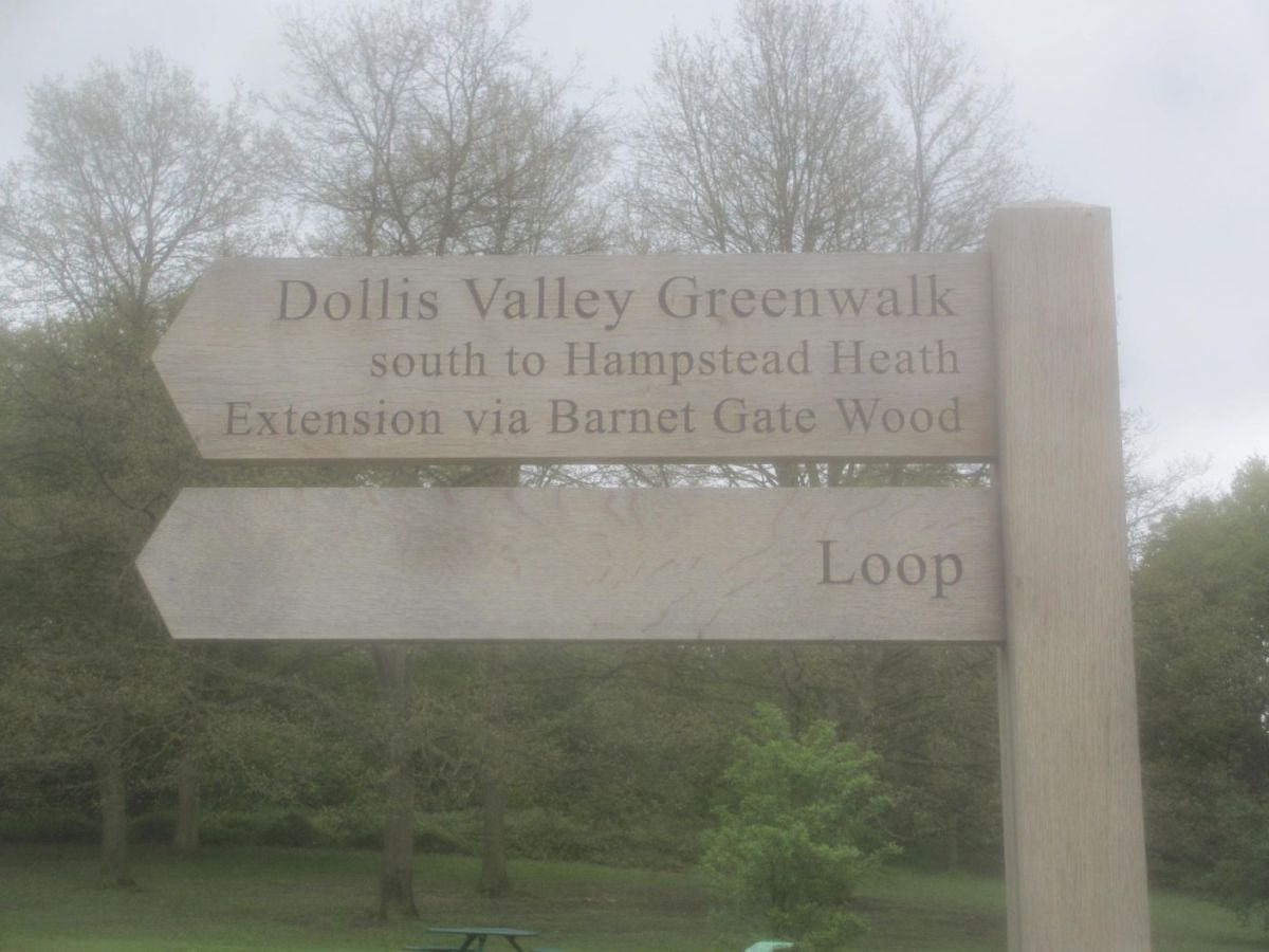
As you may have noticed from another image on this page, the LOOP is coincident with another path, in this case the Dollis Hill Greenwalk. This path is a mere ten miles, beginning here and finishing in Hampstead. I reckon a day should have knocked that off easily back then but it will have to go on the “to do” list as I still have so many others to do first. I think I’ll pencil in two days for it now.
The more I walked the LOOP and researched it for writing up, the more I discovered about the huge network of paths all over London. Some of them form the basis for other projects actually written on this site before the LOOP walk but appearing after this due to the dates undertaken, if that makes sense!
As you can see, even the unpaved sections of the path here are smooth and level and the attached website suggests it is suitable for wheelchairs and pushchairs so well done to the authorities for that.
I suppose I have a sort of subconscious notion that designated paths are a relatively modern concept but I found out that this Dollis Valley Greenwalk is based on a route called the Brookside Walk which was established by the (now defunct) Finchley Council in the 1930’s. Very forward thinking, so thank you Councillor Alfred Pike for your vision.
Exiting Moat Mount Nature Reserve, you have a short section of road walking until you enter your third Nature Reserve in as many miles. I know I keep returning to this point but for much of this walk it really is hard to believe you are in a London Metropolitan Borough, Barnet in this case.
This next natural jewel is the 97 hectares of Totteridge Fields, a designated Site of Metropolitan Importance for Nature Conservation which is administered by the Wildlife Trust. It is of interest because it is one of very few wild hay meadows left in the country, although it was not the correct season when I was there. The information board informed me that I may spot (or hear) a skylark or even a kestrel but I am afraid the only kestrels I saw were of the logo variety on the way-marks!
Regrettably, I obviously did not see quite enough of the way-mark kestrels and so I managed some way or another to stray off the path a bit. This, however, is not a problem as walking the London Loop is not like walking in inhospitable terrain where a navigational error can prove fatal. The worst thing that is going to happen here is that you might have to walk a bit further to get to the bus stop.


In my case it was not the bus stop I was looking for. I had seen a mention in my guidebook that the path was due to pass a pub called the Old Red Lion. Well, the path might pass it but I had no intention of doing so and, armed with directions from a friendly local lady, I wandered down the road until I came upon the excellent pub you see here. Despite my very best efforts whilst editing this in 2020 I can find no online reference to this establishment and I can only surmise it has either been renamed or closed as so many pubs have been since 2013. I do hope not.
Mid-afternoon on a midweek May day meant the place was not too full but I was served by a friendly barman and engaged in conversation with a couple of working blokes enjoying a pint after work. All local men obviously and yet they had never even heard of the London LOOP much less thought about doing it. I think they thought I was a bit crazed wanting to do a long-distance walk through their “manor”. This is quite a theme on my walking this path, people are almost incredulous when you tell them there is a designated long-distance path in what they consider to be their suburban home area.
More than suitably refreshed, it was time to get going again. I had decided I wanted to complete the section round to Cockfosters Tube which would make a very convenient break-point for me. Not 15 minutes after leaving the pub (I checked the times on the images) and having had to cross the hugely busy A1000 Great North Road, this is the sight that greeted me. Talk about extremes right beside each other!

This is the edge of Hadley Wood and it looks peaceful now, with a tantalising glimpse of central London in the distance. It may look peaceful now, and indeed it was a very pleasant ramble but this is approximately the site of a very important historical battle in English history, known logically enough, as the Battle of Barnet.
The battle in question took place on 14th April 1471 during the Wars of the Roses between the houses of Lancaster and York. Specifically, in this case it was between King Edward IV and his former ally, the Duke of Warwick. Whilst is was not actually decisive in the conflict (that was the Battle of Bosworth) it was a very great factor in the final outcome. It is also arguably the first battle in the UK where handguns were deployed.
Again, I learn things all the time whilst researching these pieces and I learned on 14/11/2013, whilst initially composing this that a local golf club intended to turn a large part of the battlefield into a landfill site. The idea of burying historical artefacts under tons of rubbish so the golfers can have a better playing surface was then, and is now, abhorrent to me.
I shall name and shame them (not that I suspect they have any shame) and if they want to try suing me for this comment, I welcome the opportunity to defend my comments in Court. The Golf Club is called the Old Ford Manor Golf Club and I urge any readers to have nothing to do with them. Regular readers know I like to keep things as up to date as I can and a quick online check in April 2020 shows that the environmental vandalism started in late 2018. As Bob Dylan once so rightly said, “money doesn’t talk, it swears” and I am curious as to how many of the local councillors are members there.
 I include this picture for a reason, poor quality though it is. This is a more zoomed in image of the last one and if you look you can see a lot of smudges etc. on the sky portion. This was the first time I noticed a problem with my camera, and despite many attempts at cleaning the lens it appeared to have made little or no difference, ruining what could have been a number of pretty pleasing images.
Anyway, I offer this by way of explanation and apology for the quality of many of the succeeding images which are certainly not of the quality I would have wished. However, there are no camera shops in Hadley Wood, well not to my knowledge anyway, so on I went and soon arrived at the village of Monken Hadley by way of a delightful little pond. Apart from he beauty of the water feature, don’t you just love the quaint names of British settlements? I know I do. This refers obviously to the monks who used to hold land here.
 As you look at this rural idyll which could easily be in one of the further shires remember that this is a mere 11 miles from Charing Cross which is the very centre of London and from where all distances to and from the capital are measured.
 The LOOP path does not actually go right up through the charming village but I still had a few hours daylight left and not too far to go. Besides, I had seen the wonderful building you see here and, well, it had been a bit of a walk since the Old Red Lion. Yes, you’ve guessed it, I had spied another decent looking pub, in this case the rather “olde worlde” Ye Olde Monken Holt, which turned out not to be as old as it looked (built 1863) but was still delightful. It had turned into a half decent day and I was thirsty, so only one thing for it, and in I went.

It was perhaps a little upmarket for me, I suspect this is is a fairly well-heeled part of town and I was dressed in fairly battered walking boots (over 20 years old at that point and still with four years left in them!), jeans and a fleece. I was treated pleasantly enough mind you, despite my shabby looks, and I enjoyed my pint there.
Suitably topped up, I wandered back out of the village again. Bearing in mind that I had hardly ventured into the village proper, I still managed to see a few very interesting things which I would like to share with you now.
This rather grand house was home in the 1830’s to the author Fanny Trollope, who I must confess I had never heard of and her son Anthony who I most certainly had heard of but never read. The blue plaque on the wall commemorates them.
 Just round the corner from the erstwhile home of the Trollope family is this wonderful little row of almshouses. They were endowed by a man called Roger Wilbraham in the year of his death in 1616. Born in 1553, he became a lawyer and eventually rose to the position of Solicitor General of Ireland. These lovely little dwellings were for the benefit of “six decayed housekeepers”. I am not sure who lives there now or if they are still social housing but I’ll wager that if they are currently in private hands that a housekeeper, decayed or otherwise, would not be able to afford one.
 Directly across the road from the almshouses is the Church of St. Mary the Virgin. Although there is believed to have been a church on this site for over 800 years, there is no documentary evidence before 1494. The building you see nowadays though is predominantly a Victorian restoration. I would have liked to go in for a look around as churches fascinate me but unfortunately it was locked which is all too common nowadays and a fairly damning indictment of our modern society I feel.
One very notable feature of the church is visible from the outside. If you look on the bell-tower, which still has a fully functioning set of nine bells regularly rung, there sits what is known as the Armada beacon and the Church even calls itself the “Church of the Beacon.” The story behind this is that it was one of a set of beacons stretching all over the South of England to warn of the arrival of the Spanish Armada. Whilst it is a nice story, the beacon is more likely to have been put there by monks to guide travellers over the wilds of Enfield Chase, of which more soon.
 A few yards away from the Church along Camlet Way (formerly Camlot Way although I don’t know why they felt the need to change it) the walker will come upon another sight not often seen in the environs of our capital city, a set of white gates across the road. These gates are one of five sets in the area and were put there to stop cattle wandering, would you believe?
At this point you are entering Hadley Common, part of what was once the rather larger Enfield Chase and it’s history is fascinating.
A chase is basically a hunting ground and this one was originally 3,380 hectares in size and patronised by Royalty. It is believed that before she became Queen the future Elizabeth I hunted here. Although the land was owned by the Duchy of Lancaster the local people, called commoners, had certain rights such as cutting turf and grazing cattle. Remarkably some houses in the area still have grazing rights attached to the deeds of ownership so, if you want to keep a few goats or sheep, move to Monken Hadley!
In 1777, during the reign of George III, everything changed and many such chases and other common land were enclosed. In the case of Enfield Chase it was split up between “the Crown, the four parishes of Enfield, Edmonton, South Mimms and Monken Hadley, and certain local landowners, in exchange for relinquishing their rights of common over the whole of the Chase.” However, a portion of land of approximately 70 hectares was granted to the Parish and residents of Monken Hadley and it is this that now constitutes Hadley Common which is the only enclosed portion of the original chase. Of course I knew nothing of this as I walked along Camlet Way. If you look very closely you will just be able to see the green way-mark on the lamp post in the background and so I knew I was going the right way.
Did I just say I was going the right way? Well, yes I was but I just managed to go rather too far along the right way. I should warn the walker that you need to cross the road (I knew that already) to find the entrance to the Common but could I find that entrance? Not a chance. This is a very salubrious area with lots of big houses and as I wandered up and down the same stretch of road for the third time I was sure the police were going to turn up and arrest me as a potential burglar or something.
 Eventually I managed to find the sign and was almost immediately rewarded with the delightful area you see here. As soon as I got a few yards away from the road the traffic noise was swallowed by the trees and it really was very open yet again.
 Although the LOOP is very rural for much of it’s way there is no getting away from the fact that you are fairly near to central London with all the infrastructure that implies and the next evidence of that is as shown here. This is in fact the main East coast Line which links Kings Cross to the North and Scotland. I have been on this line many, many times and next time I am going up it I shall have a look out and see if I can spot the bridge at Hadley Common.
I did wait for a while for a train but none came so I carried on. That would have made a nice image.
 As I used to be ordered in school, compare and contrast. It is hard to believe that this image was taken four minutes after the last one. This really is one of the most striking features of the LOOP, the juxtaposition of country tranquility sitting alongside major infrastructure and the hustle-bustle of big city life.
This amused me. My small day-pack wasn’t left there by accident but rather to give you a sense of scale. Why they had to make such an ornate structure over a trickle of a stream that I could easily jump over, even at my age, I simply do not know. A couple of planks would have easily sufficed. I suspect it may have been something to do with the nearby Beech Hill House. I suppose it would have taken a single horse at a pinch but certainly not a carriage or cart. Just another quirky little thing on this excellent walk.


")

")
Leaving Hadley Comon behind, I passed through another set of the cattle gates that used to enclose the Common and headed straight for the Cock and Dragon pub. As you can see from the light in the image the evening was wearing on a bit but I was honour-bound to have at least one pint in here. I had checked and knew that the Tube station was a very short distance away so it was no problem.
What looks like a very old traditional British pub from the outside (it dates from 1798) is a bit strange inside. It is a huge place and about half of it serves as a British pub whilst the other half is given over to being a Thai restaurant with all the attendant Asian trappings. I did not eat but the food I saw being served looked very good.
One thing I did notice as I was standing outside having a smoke was this rather attractive clock and weather-vane. I wonder if it was part of the original structure. The clock was keeping good time and you can see it was getting late so I took my leave and headed towards the Tube and journey’s end for that day.
A brief walk took me to Cockfosters Tube station. If you have ever caught a Tube into London from Heathrow you will probably have seen the name Cockfosters as this is the terminus of the Piccadilly Line at the opposite end of the line to the airport.


The station was opened in 1933 having been built to the design of Charles Holden who was a prolific architect of Tube Stations. It is apparently in a modern European style although I had to look that up later. It is certainly nowhere near as grand as some of his other work but it does look very 1930’s even to my untutored eye.
So that was it for another day’s walk. I had had a good day’s exercise, seen some fascinating things, visited several fine pubs and so it was a tired but happy Fergy that got on the Tube and headed home.
There will be much more of the same sort of nonsense as I knock off a further few LOOP miles in the next instalment so stay tuned and spread the word.
